
Trimble X9 3D Laser Scanning System
What is a Trimble X9 Scanner and How Do I Use It?
The Trimble X9 is a versatile and powerful laser scanner that can be used for a wide range of applications, including as-builts, land title surveys, and mobile mapping. The X9 features a high-resolution sensor that can capture up to 1 million points per second, as well as a wide field of view that allows you to capture large areas in a single scan. The X9 also includes a number of advanced features, such as auto-classification and annotation, that make it easy to process and visualize your data.
What are the key features of the Trimble X9 Scanner?
- High-resolution sensor with up to 1 million points per second
- Wide field of view for capturing large areas in a single scan
- Advanced features such as auto-classification and annotation
- Versatile and powerful laser scanner that can be used for a wide range of applications
If you are looking for a high-performance laser scanner that can help you capture accurate and detailed data, the Trimble X9 is a great option.
Versatile advanced scanning and imaging you can depend on.
The power to do more.
Do more, better, faster with the range, accuracy and short scan times you need to boost productivity.
That’s the power of the Trimble® X9 laser scanning system. Capture reality in minutes for a job done right the first time
Trimble X9 3D laser scanner features
Dependability
- Self calibrating for dependable data every scan.
- Survey grade self leveling for fast, easy setup.
- IP55 environmental protection against dust and water.
- Wide operating temperature range to keep you working all year long.
Performance
- Fast scan times of less than 1 minute can be reached for fast project completion.
- 150 m range to put more projects within reach.
- High accuracy and low range noise point cloud data for detailed digital twins.
Versatility
- High speed scanning up to 1 million pts/s.
- Better range, angular accuracy and data quality to support a wider range of applications.
- Enhanced sensitivity for standard scans to capture difficult dark or shiny surfaces.
- Flexible operation with tablet, phone, or one-button workflow.
Trimble Perspective Software
- In-field registration.
- In-field 3D data visualization.
- Georeferencing with laser pointer and precision point.
- Area scan for higher density on critical areas
Trimble X9 Applications
The Trimble X9 quickly captures features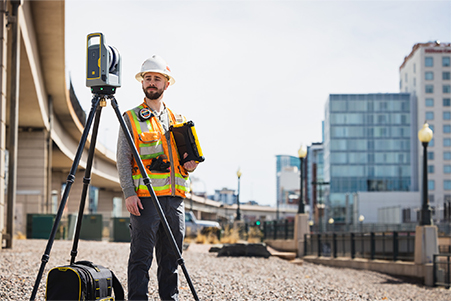 for land title surveys, buildings, roads, intersections, site improvements, encroaching elements and complex structures:
- Document and highlight features or items of interest using annotations.
- Assign labels to each scan to create logical scan groups and annotations with pictures while scanning the next station.
- Use auto-classification tools in Trimble’s office software to extract data corresponding to the ground, buildings, powerlines, signs, vegetation, and more.
- Create as-builts of road corridors, intersections, roadway surfaces, lane striping, flow lines, manholes, right of ways, overhead power lines, and other features.
With the Trimble X9, you can create as-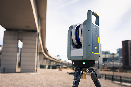 built documentation for drawings or models for bridges, tunnels, dams and other civil infrastructure with a range that allows for operation from a safe distance, while the area scan feature provides high-resolution data on areas of interest. Also use it to:
- Incorporate scan information in clearance calculations, modeling, inspections, renovations, and expansion work.
- Leverage high-speed data capture and quickly capture area scans to reduce downtime for critical infrastructure projects.
- Benefit from HDR image quality for visual inspection and sharing of information.
- Register in the field to verify scan data is complete before importing to Trimble Business Center or Trimble RealWorks at the office
The Trimble X9 enables users to create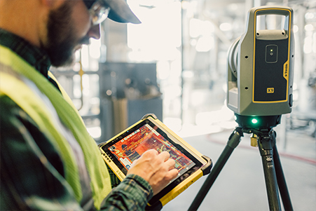 accurate as-builts of complex industrial facilities for modeling and revamp designs. Also use it to:
- Take high-resolution area scans for more detail on points of interest and safely capture inaccessible areas from a distance.
- Benefit from high sensitivity to capture dark and reflective surfaces.
- Enhance in-field documentation with annotations and pictures of tie-in locations inside Trimble Perspective.
- Georeference scans to plant coordinate systems using Trimble RealWorks target-based registration and survey control for export-to-plant design software to do piping layouts, check fabrication spools, and detect interferences with CAD models.
The Trimble X9 helps you plan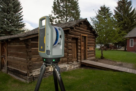 restoration efforts or simply capture history. Historic preservation projects require great detail to inspect or monitor surface deterioration as well as HDR imagery for documentation, analysis and restoration. Also use it to:
- Retain important details with high-resolution area scans on points of interest and safely capture inaccessible areas from a distance.
- Digitally preserve fragile structures for re-creation.
- Document and share the site with panoramas and clear color imagery.
Add annotations in the field with images to highlight critical areas of interest back in the office. - Check data quality before leaving the site to eliminate costly and time-consuming field revisit
For forensics applications, use the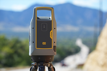 Trimble X9’s high-speed scanning and imaging to capture information at crime scenes and vehicular accidents and minimize road closures, even in extreme weather conditions. Also use it to:
- Benefit from high sensitivity for dark and reflective surfaces.
- Add annotations with pictures to points of interest and take measurements in the field.
- Benefit from automatic field calibration with reporting for court documentation.
- Register in the field to verify complete data capture before leaving the scene.
- Export data to Trimble Forensics Reveal software for creation of 2D/3D diagrams and animations for investigation and reconstruction.


