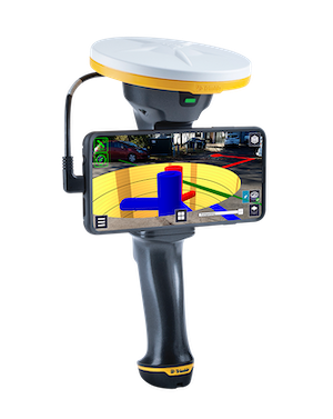
Trimble SiteVision
The power of information reimagined
Trimble SiteVision is a user-friendly outdoor augmented reality system that brings data to life so you can visualize and explore complex information with unrivaled accuracy.
Imagine if you could see things that are hidden or that don’t actually exist yet. With the Trimble® SiteVision™ outdoor augmented reality system you can. SiteVision brings geospatial data to life so you can easily visualize, explore and understand complex information with unrivaled accuracy, right from your mobile device.
Take a walk through your job site and visualize:
- Conceptual designs, from buildings to roads, as they might appear in real life
- What lies beneath the ground or resides inside walls, such as water pipes and electrical cabling
Provide real world context to your designs:
- Communicate complicated plans and drawings
- Precisely identify where concealed assets are
- Minimize costly errors and safety related incidents
Simply upload your data, visualize and manipulate it in the field, and report back to the office—all through the Trimble Cloud.
Streamlined, integrated solution
- Centimeter-accuracy GNSS positioning with the Trimble Catalyst™ software-based receiver
- Remote measurement with an Electronic Distance Measurement (EDM) rangefinder
- Flexible design fits user-supplied Android™ 9 phones (up to 8” screens)
- Waterproof and rugged
- Works handheld or pole-mounted
Easy-to-use software brings data to life
- Automatically place models on site, with centimeter-level accuracy
- View fully textured models in 3D, plan view or cross-section
- View any attributes in your model
- Adjust model opacity or cross-section to understand context
- View subsurface models with PitView
- Works seamlessly with your existing workflows and data; supports Trimble, open industry standard, and third-party file types: Trimble Business Center, SketchUp, Esri, AutoCAD


